Trending
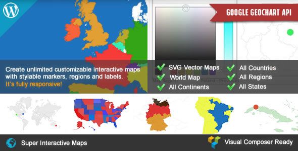
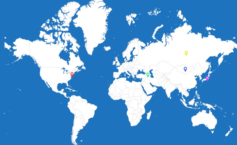

Super Interactive Maps for WordPressSuper Interactive Maps is a fully-featured WordPress Plugin integrated with Google Geochart API that allows you to create maps of country, continent and regions. Create custom markers on top of your map to show location of interest such as hotel, cafes, airport and others. You can add interactivity to your map such as displaying interactive tooltips, lightbox window or linking to a web page content.
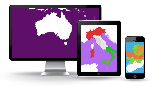
This is a responsive plugin and fully compatible with the latest WordPress version and Visual Composer.
" style="text-align: justify;">Google Geochart API that allows you to create maps of country, continent and regions. Create custom markers on top of your map to show location of interest such as hotel, cafes, airport and others. You can add interactivity to your map such as displaying interactive tooltips, lightbox window or linking to a web page content.
This is a responsive plugin and fully compatible with the latest WordPress version and Visual Composer.
" style="text-align: justify;">
This is a responsive plugin and fully compatible with the latest WordPress version and Visual Composer.
If you buy this mint (i.e source code) now, you will get lifetime mint updates for free.
This is a responsive plugin and fully compatible with the latest WordPress version and Visual Composer.
Main Features
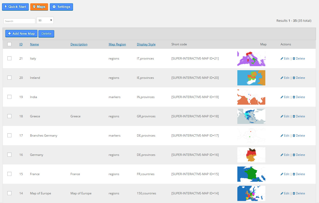
- Includes over 300 maps all in a one plugin
- All 195 countries world-wide included
- Easily create SVG and vector maps on your WordPress site
- Fully responsive and works on all mobile devices (cross device and browser compatible)
- Vector Maps of World Map, Continent or Subcontinent including Africa, Europe, Asia, Oceania, Africa, South America, and Americas
- Vector Maps of India, China, Turkey, Romania, Japan, Spain, Italy, France, Canada, Germany, UAE, Syria, Iceland, Poland, Malaysia, Australia, Mexico, Brazil, Indonesia, Nepal, UK, US, Russia and all countries included
- Vector Maps of all countries divided by regions
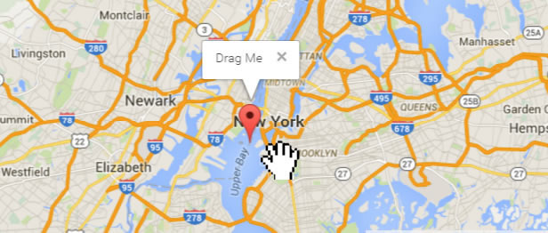
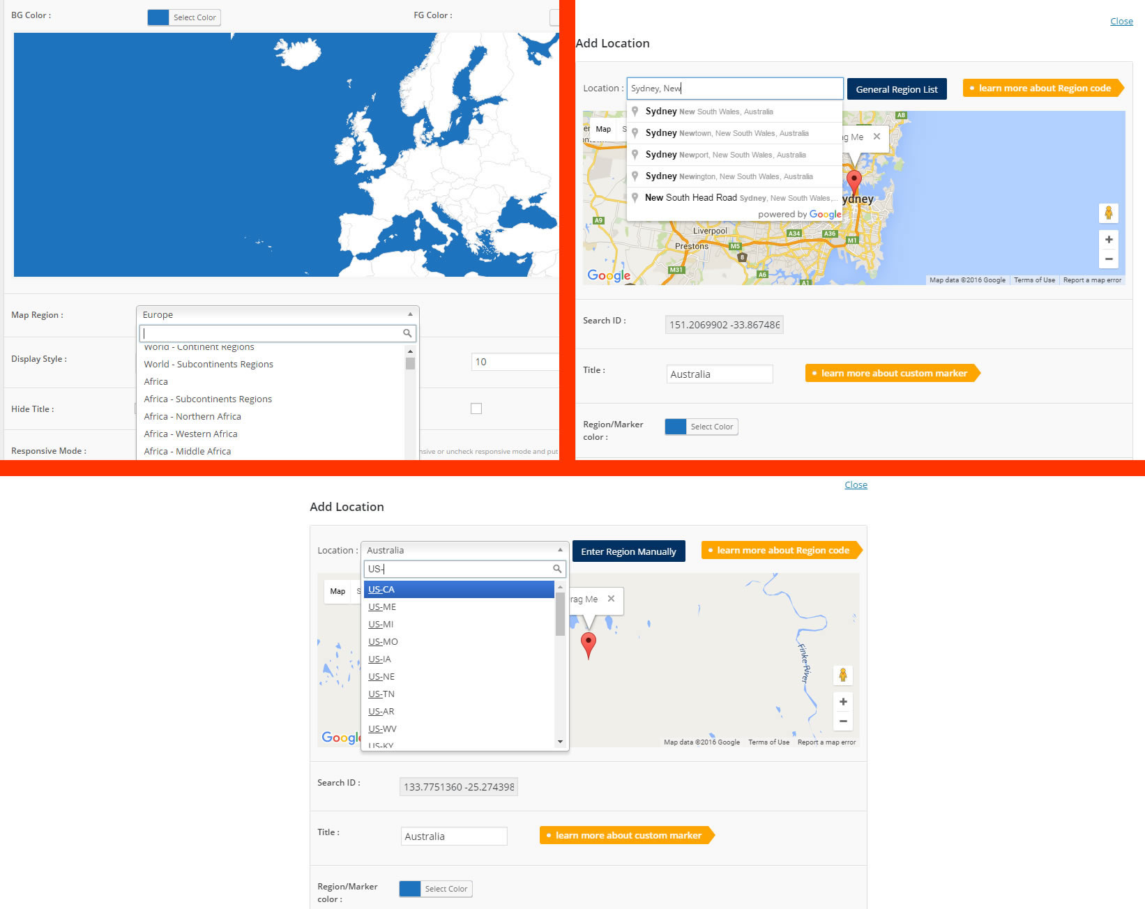
- Autocomplete Search to easily add locations
- Pin point to the exact location using the drag and drop marker feature (Admin integrated with Google Maps API)
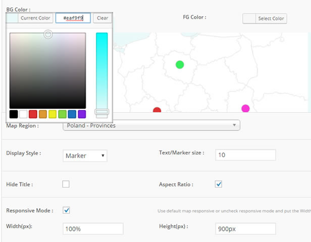
- Customizable map designs, styles and colors
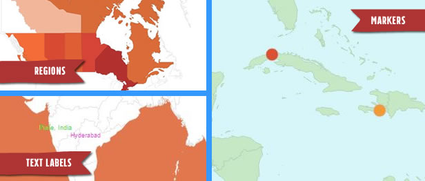
- Choose your display styles (Regions, Markers or Text Labels)
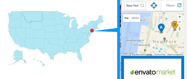
- Interactive responsive lightbox popup to showcase rich content such as text, images and videos
- Add interactive tooltip to maps
- Zoom and Pan your map display
- Display custom map markers on your map
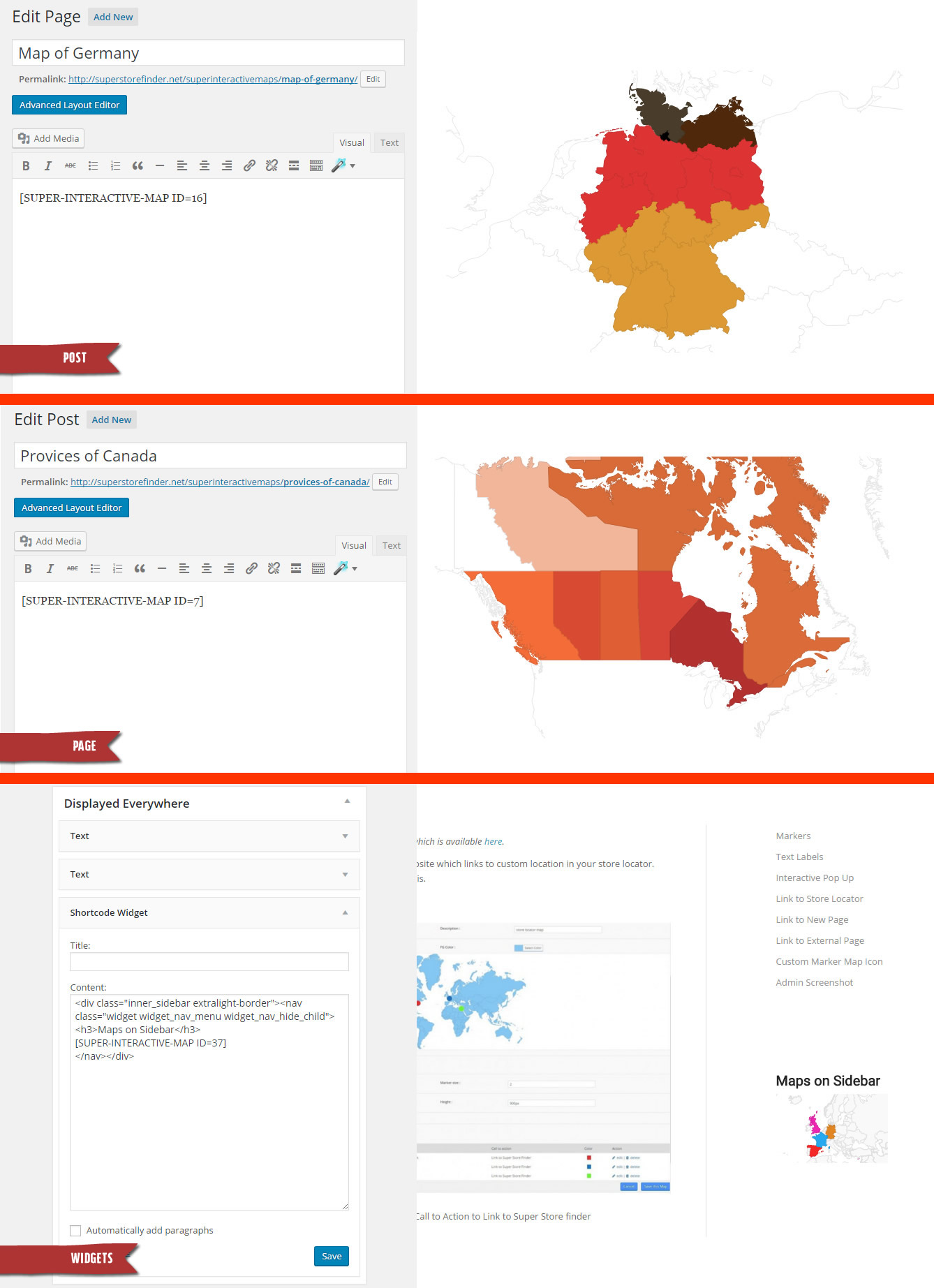
- Post shortcodes anywhere on your website including posts, pages and sidebar widgets
" style="text-align: justify;">Google Geochart API that allows you to create maps of country, continent and regions. Create custom markers on top of your map to show location of interest such as hotel, cafes, airport and others. You can add interactivity to your map such as displaying interactive tooltips, lightbox window or linking to a web page content.
This is a responsive plugin and fully compatible with the latest WordPress version and Visual Composer.
Main Features
- Includes over 300 maps all in a one plugin
- All 195 countries world-wide included
- Easily create SVG and vector maps on your WordPress site
- Fully responsive and works on all mobile devices (cross device and browser compatible)
- Vector Maps of World Map, Continent or Subcontinent including Africa, Europe, Asia, Oceania, Africa, South America, and Americas
- Vector Maps of India, China, Turkey, Romania, Japan, Spain, Italy, France, Canada, Germany, UAE, Syria, Iceland, Poland, Malaysia, Australia, Mexico, Brazil, Indonesia, Nepal, UK, US, Russia and all countries included
- Vector Maps of all countries divided by regions
- Autocomplete Search to easily add locations
- Pin point to the exact location using the drag and drop marker feature (Admin integrated with Google Maps API)
- Customizable map designs, styles and colors
- Choose your display styles (Regions, Markers or Text Labels)
- Interactive responsive lightbox popup to showcase rich content such as text, images and videos
- Add interactive tooltip to maps
- Zoom and Pan your map display
- Display custom map markers on your map
- Post shortcodes anywhere on your website including posts, pages and sidebar widgets
" style="text-align: justify;">
Super Interactive Maps for WordPress
Super Interactive Maps is a fully-featured WordPress Plugin integrated with Google Geochart API that allows you to create maps of country, continent and regions. Create custom markers on top of your map to show location of interest such as hotel, cafes, airport and others. You can add interactivity to your map such as displaying interactive tooltips, lightbox window or linking to a web page content.This is a responsive plugin and fully compatible with the latest WordPress version and Visual Composer.
Main Features
- Includes over 300 maps all in a one plugin
- All 195 countries world-wide included
- Easily create SVG and vector maps on your WordPress site
- Fully responsive and works on all mobile devices (cross device and browser compatible)
- Vector Maps of World Map, Continent or Subcontinent including Africa, Europe, Asia, Oceania, Africa, South America, and Americas
- Vector Maps of India, China, Turkey, Romania, Japan, Spain, Italy, France, Canada, Germany, UAE, Syria, Iceland, Poland, Malaysia, Australia, Mexico, Brazil, Indonesia, Nepal, UK, US, Russia and all countries included
- Vector Maps of all countries divided by regions
- Autocomplete Search to easily add locations
- Pin point to the exact location using the drag and drop marker feature (Admin integrated with Google Maps API)
- Customizable map designs, styles and colors
- Choose your display styles (Regions, Markers or Text Labels)
- Interactive responsive lightbox popup to showcase rich content such as text, images and videos
- Add interactive tooltip to maps
- Zoom and Pan your map display
- Display custom map markers on your map
- Post shortcodes anywhere on your website including posts, pages and sidebar widgets
If you buy this mint (i.e source code) now, you will get lifetime mint updates for free.
What We offer:
Get final year project research topics. Browse free project topics and research material for final year students and researchers on Codemint. Start now.Talk to us right now: (+234)906-451-7926 (Call/WhatsApp)
You can find more topics easily, just search
Regular License
Regular License
Selected
₦20,000
Use, by you or one client, in a single end product which end users are not charged for. The total price includes only the mint item price.
₦20,000
Related Code Scripts


© All Rights Reserved CodeLord
Contact the CodeMint Market Help Team
Contact the CodeMint Market Help Team